


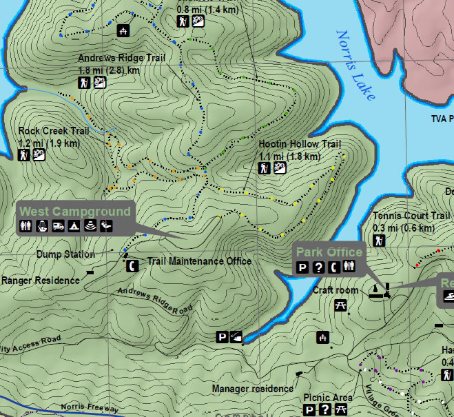
Norris Dam State Park makes a perfect stop for your Tennessee vacation and offers plenty of options for nature lovers! Hootin Hollow Trailhead is part of the Andrews Ridge Trails System. Be sure to check out the Norris Dam State Park map for information on all the available hiking trails, camping sites, picnic and recreation areas, marina, visitors center and more! The map is available for download below.
Hootin Hollow Trailhead Hike

View of the entrance to Hootin Hollow Trailhead. This trail is only .23 miles but is .65 miles if you walk the trail to the entrance inside West campground. Parking is located on the side of the road next to the Trail Maintenance office. If you continue past the visitors center it will lead you inside West campground where you can also access the trail.

Hootin Hollow Trailhead offers gradual sloping terrain that is easy for beginner hikers. This trail also offers resting areas.

Hootin Hollow Trailhead leading to West Campground at Norris Dam State Park.

View of at the end of Hootin Hollow Trailhead at West Campground entrance at Norris Dam State Park. You must now walk through the campsite and down the road to get back to the Trail Maintenance office.
Norris Dam State Park Map
Directions
To get to Hootin Hollow Tailhead from Norris Freeway exit drive via TN-71 N/TN-71 Scenic N/US-441 N/US-441 Scenic N/Norris Fwy and follow till you get to Andrew Ridges Road inside Norris Dam State Park. Follow the road and park at the Trail Maintenance office on the right. Straight ahead is entrance to West Campground.
Norris Dam State Park
125 Village Green Circle
Rocky Top, TN 37769
Telephone: (865) 494-7461
Website: www.norrisdamstatepark.org
Park Activities: boating, cabin rentals, camping, fishing, hiking trails, marina, picnic facilities, swimming, summer programs, national trail day, wildflower hikes, fall color boat cruises, junior ranger camp, pickin in the park, public lands day
Have a question or comment about Norris Lake? Feel free to share your thoughts and comments!


